Monday 30 May 2016

Arctic Lands/The North Region

Geography


A map showing all of the geographic regions of Canada


A map showing the latitude and longitude of Canada

Canada's Arctic Lands were formed by glaciation over much of Northern Canada. This region is North of the tree line and has little plant life. A great part of the Arctic Lands is made up of rocks, specifically igneous, metamorphic, and sedimentary rocks. Most of the land in this region is covered in permafrost, and only thaws out for a few months of the year. Lowlands, plateaus, ice caps, and mountains are all found in this region. In the South, there are plains and small, rolling hills. In the North, there are glaciers and mountains, which are made up of bedrock outcrops. Most of the islands in this region are made up of folded sedimentary rocks, producing mountains on the islands. A unique land form found in the Arctic Lands is a pingo. 

Climate

The average Winter temperature in the Arctic Lands in -34 degrees Celsius, and in the Summer, the average temperature is 3 - 12 degrees Celsius. Most of the precipitation in this region comes as snow, and there is usually less than 10 inches each year.


Climograph of Hall Beach, NT

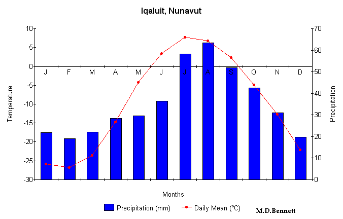
Climograph of Iqauit, NT
Climograph of Grise Fjord, NT

The active layer of soil that thaws out in the Summer is not very deep, but the permafrost layer can go as deep as 650 meters below the ground. The soil in this region can be classified as either Gelisols or Cryosols, which means that the soil is easily eroded, and have permafrost with an active layer on top. The climate here is like this because the arctic is tilted away from the sun, so it does not get as much heat as other regions. Climate change has mainly had a negative impact on the Arctic Lands region. For example, Arctic sea ice, glaciers, and permafrost are all melting. The thickness of sea ice has decreased by half over the past 60 years and glaciers all over the world are getting smaller and smaller. This could potentially change ocean circulation. This, along with the melting permafrost, could rise sea levels, threatening wetlands, coral reefs, and coastal communities.

Flora And Fauna

Although no big plants or trees grow in the Arctic Lands, there about 1700 different kinds of small, shallow-rooted plants that do grow, including lichens, grasses, mosses, flowering plants like purple saxifrage, mountain avens, arctic poppies, and buttercups, and dwarf shrubs, which are low-growing, woody plants. These plants can grow in this extreme environment because their shallow roots only need the thin, thawed out part of the ground to grow. Other ways that plants have adapted to the cold include growing close together to preserve heat, fuzzy coating on the stems, leaves, and buds, and cup-shaped flowers that face up, so the sun's heat is directed at the flower.

One of the many types of Lichen found in the Arctic Lands

Many animals also live in the Arctic Lands, such as caribou, lemmings, musk oxen, arctic foxes, wolves, and polar bears. These animals have very thick fur coats to help keep them warm. Some animals also live in the water, like walruses, seals, whales, and many types of fish. Mammals that live in the water have a layer of blubber to keep them from freezing to death. The fish keep themselves from freezing by producing an antifreeze-like protein in their blood. Many types of birds also migrate the Arctic Lands in the Spring months to nest and raise their young. While most birds fly South in the Fall, the ptarmigan stays all year round.

A polar bear in the Arctic Lands

Human Geography

The population of the Arctic Lands is very small, only about 14 000, and spread out, mostly because it is very hard to survive in the type of environment the region presents. For example, the city of Grise Fjord has a population of only 163 people, and all of Nunavut only has 28 cities. Some major cities in the Arctic Lands are Iqaluit, with 6200 people, Inuvik, with 3484 people, and Hall Beach, with 736 people. Most people who live in the Arctic Lands are Inuit people, and they have lived in the region for thousands of years. They hunt seals, caribou, and whales for food, and they also trap and fish. The Inuit made boots, parkas, and pants out of caribou hide and sealskin.  Humans have also found uranium, nickel, copper, zinc, silver, gold, and diamonds in the Arctic Lands as well as oil and natural gas.  The Inuit build landmarks called Inuksuits using rocks to guide hunters and travellers.


Two Inuit people hunting for seals
An inuksuit built by the Inuit

Economy

In the past, the economy of the Arctic Lands was built around fur trading, whaling, sealing, the gold rush, and mineral exploration. The search for the Northwest Passage also attracted many Europeans. Today, the economy is mainly built around oil and mining. The Ekati Mine produces 4 million carats of diamonds each year, but the 1998 projection suggested that in 2015, the mine may begin to run out. Oil companies have been trying to get as much oil as they can, but the environmental challenges of the region have made this very hard. For example, artificial islands were built on the Beaufort Sea to get at its oil, but the pressure from the arctic ice makes it hard for them to operate efficiently. As a result, it is hard for the industries in the Arctic Lands to export their goods and make expand the economy. The only major uses of natural resources in this region are oil and diamonds. 


A bird's eye view of the Ekati Mine


Environmental Concerns

A major environmental concern in the Arctic Lands is air pollution. Pollutants such as organochlorines and heavy metals are carried into the arctic on air currents from densely populated areas. Several plant forms, especially lichens, are harmed by this. Lichens are so vulnerable to air pollution because they don't have roots, so they get the majority of their nutrients from the air. Because of this, lichens are commonly used as a natural air pollution detector. Air pollution also causes acid rain, which speeds up the melting of the arctic ice. Humans have influenced this problem because we are the only ones that create air pollution. Some solutions to this problem are to use cleaner fuel, such as natural gas, using less fuel, encouraging mass transit like buses, and producing pollutant-resistant strains of vegetation. Some conflicts in promoted solutions are present because solutions to one problem can cause more problems for another. For example, electric cars would reduce air pollution in cities, but would cause other problems with the disposable of the batteries and the emissions from the power stations. Also, the replacement of CFCs, chlorofluorocarbons, with other gases could reduce ozone depletion, but would cause other problems with climate change. I believe the best solution to this problem is to just try to reduce the amount of air pollution as best we can by riding bikes, taking buses, carpooling, walking, or anything else we can think of.     

Comparison To Another Location

Another place in the world that is similar to the Arctic Lands is the Siberian Tundra. Like plants and animals of the Canadian Arctic Lands, plants and animals here also have adapted to their environment by growing close together, growing close to the ground, having shallow roots, and having thick fur or blubber. Humans there hunt and trap animals for food.

Climograph of Surgut, Russia

The biggest economic activities in the Siberian Tundra are, like the Arctic Lands, oil and mining, which have put much pollution into the air. Other economic activities in the Siberian Tundra include aluminum refining and pulp making.

Cordillera/British Columbia

Geography


A map showing all of the geographic regions of Canada

A map showing the latitude and longitude of Canada


The Cordillera was formed when two tectonic plates crashed into each other, lifting sections into the air and creating mountains. Pressure from these plates also formed valleys, trenches, and plateaus. Erosion from rivers and glaciers further further sculpted the landscape. In the East, the rocks in the Cordillera are mostly sedimentary rocks that have been twisted and folded. In the interior and Vancouver Island, the rocks are mostly sedimentary and volcanic rocks. In the West, there are igneous and metamorphic rocks. A unique feature of the Cordillera is the gentle rolling of the inland plateaus. This land feature was formed by glaciation, erosion, and lava flows from volcanoes that used to be active in the area. What makes the Cordillera different from other regions is its mountainous, irregular terrain and its great variety of climates, soils, and vegetation.

Climate

Because of the varying climates of the Cordillera, there are different levels of temperature and precipitation depending on where you are. In the Northern Cordillera, temperatures range from -22 degrees Celsius in the Winter to 8 degrees Celsius in the Summer. The North get about 250mm to 300mm of precipitation each year. In the central Cordillera, the average temperatures are -18 degrees Celsius in the Winter and 10 degrees Celsius in the Summer. The West/Central Cordillera gets about 300mm of precipitation each year, while the East/Central Cordillera can get up to 1500mm. The South Cordillera can receive anywhere from 300mm to 1500mm of precipitation each year, and the West Coast can get up to 4000mm. The average Summer temperature in the South is 19.5 degrees Celsius, and the average Winter temperature is -12.5 degrees Celsius.


Climograph for Kamloops, BC

Climograph for Peace River, BC

Climograph for Prince Rupert, BC

As with the temperature and precipitation, there are also different types of soil in the Cordillera. For example, in the mountains, the soil is very rocky and acidic, making it difficult for anything to grow, which is why mostly lichens and mosses grow in these areas. The soil in the plains are more nutritious, making it easier for things to grow there. Mostly grasses and grassland vegetation are grown in this area. In the Central Cordillera, the soil is very rich, allowing much vegetation of varying types to grow. In the Western Cordillera, there is a rainforest because of the mountains on the coast. There is not as much rain in the Interior because of the rainshadow cast by the mountains. The climate in the Cordillera is caused by Easterly moving air masses. These air masses cause the cold Winters and the hot Summers. The type of climate change that will affect this region the most is global warming. It will cause the snow on the tops of tall mountains to melt, which could rise the sea level, potentially threatening coastal communities and other wetlands.   

Flora And Fauna

The Cordillera has many types of plant life, mostly because of the amount of different climates the region possesses. Plants in the Cordillera region include black spruce, white spruce, sedges, lichens, large-flowering plants, and mosses. Lichens, mosses, and sedges have adapted to their environment by being able to grow on the rocks of the mountains. Flowering plants have adapted by having large flowers to both attract insect pollinators during the short growing season and to get as much sunlight as possible.

A forest in the Cordillera region, showing many different kinds of plant life

The Cordillera has just as much diversity in its animal life as its plant life, with many kinds of animals roaming the lands. Some of the animals in this region are: Dall's sheep, mountain goats, wolverines, grizzly bears, golden eagles, and cougars. The Dall's sheep and mountain goats have adapted to their region by having hooves like suction cups to help them climb steep mountains. The cougar, which hunts these two animals, is also good at climbing. The grizzly bears of the region have adapted by developing omnivorous habits, meaning they eat both plants and animals, making it easier for them to get enough food to survive.

A grizzly bear and its cub in the Cordillera region

Human Geography

The total population of the Cordillera is about 4 123 200 people, most of them residing in the Vancouver area. In the North, the population of the Cordillera is very small and spread out, numbering only about 400 people. However, as you go South, the population gets much denser and higher, with cities like Vancouver having over 1 000 000 people. Other major cities in the Cordillera include Kamloops, Kelowna, Prince George, and Abbotsford. Humans use the natural resources of this area mainly for forestry, mining, and farming. For example, cattle grazing is a big industry in the South, as are forestry and mining. However, a downside to this is that the rising population of the South means that more resources are needed, which results in the depletion of natural resources in the Cordillera. 


A group of First Nations people who live in the Cordillera region

 
Economy

In the 1800s, the economy of the Cordillera was built around forestry. BC shipped wood all over the world, and still does to to this day. Today, the biggest industry in the Cordillera is still forestry, and other industries include agriculture, mining, and fisheries. By the mid-90s, $1 500 000 000 worth of forestry products had been exported from Canada. About 30 000 people are employed in forestry-related jobs in BC. The forestry industry has risen and fallen with the economy, but now, however, people are focusing more on the trees themselves rather than the money, wanting to make sure that trees will always be a resource for Canada. There have been some disputes, especially about the cutting of old-growth forests, but Canada has been doing relatively well in preserving the forests, passing numerous Acts to help sustain the forests of BC.

An example of forestry in BC

The fisheries, however, are not doing so good. The backbone of the fishing industry are the salmon: sockeye, pink, coho, chum, and spring. The salmon of BC have been overfished to the point of near extinction. For example, the Snake River Chinook run was about 1 500 000 salmon in the 1800s and only 2500 today. In addition to overfishing, logging, mining, road building, dam building, and urban sprawl have all affected the salmon's spawning areas. In an effort to help sustain the salmon, Canada cut its commercial salmon fishing fleet in half in 1996. Other attempts at sustainability include licence buyback scheme, which is the government purchasing back the fishing licences it has sold, and fish farming, which is the raising of salmon in a controlled environment.

An example of commercial salmon fishing in BC

Agriculture has long been practiced in BC, and even though only 10% of its land is suitable for it, this industry is more stable than forestry and fisheries. While it is still vulnerable to periods of crisis, and is not as major as the two aforementioned industries, the agriculture industry is an overall very stable industry in the sense that farms are not going to disappear any time soon. In fact, farming in BC is fast becoming more of a big business than a little family business. The most prosperous farming places in BC are the Fraser and Okanagan Valleys. The only big problem in the agriculture industry was in the 1960s and 1970s, when more and more people were moving into the farmland and industrializing it, shrinking the already small amount of farmland in BC. As a solution to this issue, 4 700 000 hectares of land were reserved for agriculture purposes only.

Two farmers harvesting their carrots


Finally, mining is also a big industry in the Cordillera. Gold, copper, lead, and zinc are all mined in BC. The unprocessed minerals that are mined are exported all around the world. The average lifespan of a mine in BC is about 25 years. Although most mines in BC are underground, open-pit mines are also becoming popular, as they are safer than underground mines and require fewer workers. A downside to open-pit mining is that is can be very harmful to the environment by leaving behind waste from the mine, polluting nearby rivers and streams, and polluting the air. The government was tried to help lessen the effects of these problems by ensuring that the area of the mine is left in a healthy state and trying to cut down acid rock drainage, which occurs which the rock left over in a mine is exposed to air, which in turn makes sulphuric acid.

An open-pit mine in the Cordillera region


Environmental Concerns

An environmental concern in the Cordillera region is the diminished supply of wild salmon. As mentioned earlier, salmon have been overfished for years, as well as having their spawning grounds contaminated by urbanization and other industrial projects. Humans, especially those of European descent, have influenced this problem because they are the ones who started overfishing and harming the fish's habitats. Since salmon are a keystone species in BC, if they were to be fished to extinction, it would greatly damage the ecosystem. Some solutions that have been suggested to solve this problem are salmon farming, limiting fishing, both commercial and sport, and restoration of the spawning grounds of the salmon. However, some of these solutions have also presented new problems. For example, farmed salmon can hurt the wild salmon population even more by spreading diseases that are limited to the farms to wild salmon. Although this can only happen if a fish escapes from the fish farm, still poses a concern. Also, some First Nations Peoples have been angered by the limited fishing rule because they are guaranteed right to fish whenever and however they want. This has led to many disputes between the First Nations and the government. I believe the best way to solve this problem is to educate everyone we can about this issue, so people will understand why they can only catch a certain number of fish or only fish in certain places. This could stop people from complaining about the limits and maybe even convince to people who go over to stop.

Comparison To Another Location

Most of the Cordillera region is boreal forest, with only the west coast being a temperate rainforest. Another boreal forest biome outside of Canada is the Russian Taiga region. Much of the same plants and animals live there, and in turn have the same adaptations, such as thick fur to keep warm and shallow roots to grow in thin soil. 


A climograph of Moscow, Russia

Like the Cordillera, the major economic industry in the Russian Taiga is forestry. Many people in the are rely on forestry, specifically timber forestry, and some types of agriculture to get what they need to survive. Many traditions in the area are also involved with the forest, so it is vital that it remains maintained.

Interior Plains/The Prairie Region

Geography


A map showing all of the geographic regions of Canada

A map showing the latitude and longitude of Canada


The Interior Plains have miles upon miles of rolling hills, and these were caused by glaciation from the last Ice Age.  This is evident by the glacial deposits in the area, such as moraine and former glacial lakes. Further sculpting of the land was caused by erosion. The land in this region is mostly made up of sedimentary bedrock, which consists of shale, siltstone, and sandstone. All of the oil, fossil fuels, and natural gas deposits were caused by deposits of decomposed plants and animals being crushed and compressed by the sedimentary rocks. Unique features of the Interior Plains are the peat-covered plains in the valleys of the Hay, Athabasca, and Peace Rivers, which are also evidence of glaciation in the area.

Climate

The Interior Plains are a relatively cool region, with the average temperatures in the Winter range from -9.4 degrees Celsius to -18.3 degrees Celsius, depending on where you are in the region. In the Summer, the average temperature is about 19.7 degrees Celsius. However, the temperatures can get much higher and much lower, up to 40 degrees Ceslius and down to -40 degrees Celsius. The prairies are also quite dry, only receiving between 300mm to 500mm of precipitation each year.


Climograph of Edmonton, AB
Climograph of Winnipeg, MB

Climograph of Regina, SK

In the Interior Plains, Summers are often short and the Winters are very long. The soil in this region is mainly Chernozemic soil, which means that it is dark coloured and has a high percent of humus, ammonia, phosphorus, and phosphoric acids. The soil is dark coloured because of the accumulation of organic matter in the root zones of the grasses in the region. This region is so dry because of the Rocky mountains creating a rainshadow over this region. While most effects of climate change in this region, like flooding, drought, hailstorms, and grass fires, are harmful, some are actually helpful. For example, the warming climate causes longer and warmer growing seasons.  

Flora And Fa
una

The plants in the Interior Plains are almost all grasses, be it bluestem grass, porcupine grass, or june grass. Bluestem grass grows up to 10 feet tall, porcupine grass grows 8 feet fall and has a bloom at the end, and june grass grows 2 feet tall, and has either green, silver, or yellow coloured flowers. Other plants in this region include fir trees, pine trees, spruce trees, cottonwood trees, lichens, mosses, and varying types of shrubs. Since the prairies are very dry and susceptible to fires, the plants here have developed many adaptations to help them survive. Some of the adaptations include deep and extensive roots, which can help them survive fires and get more nutrients from the ground, narrow leaves to reduce evaporation, small flowers in dense heads that are pollinated by wind, and an ability to photosynthesize without losing moisture.


June grass in the prairies

There are hundreds of different species of animals that live in this region, and they have all adapted to this environment the best they can. For example, animals like elk, deer, and bobcats find shelter in river valleys or similar environments find find shelter from the Summer's heat and the Winter's cold. Other mammals in this area, like badgers, squirrels, and gophers, have adapted by borrowing holes in the ground to escape the heat/cold. Reptiles, like snake and lizards, and amphibians like toads hibernate underground during the Winter. In the past, bison grazed on the prairies and were hunted by natives, bears, and wolves. Now the prairies are mainly grazed by domestic livestock.


A wild bison grazing on the prairies

Human Geography

The Interior Plains have a total population of about 5 348 350 people, with most of them residing in the Southern area of the region. The North still has a population of around 22 000 people, but the colder temperatures and smaller land area have caused the population to be much less dense. The central area of this region sees an increase in population to about 812 000 people. This is mainly because of the warmer climate and more arable land. However, in the South, there is a leap in population to around 4 514 100 people. There are so many more people here than the rest of the region because of the ideal farming conditions, the oil field, and the close proximity to the United States, which provided more trading opportunities when the region was just being settled. For this reason, most of the major cities in this region are in the South. The major cities include Edmonton, Calgary, and Winnipeg. Most of the major industries in the Interior Plains are based off the natural resources found in this area, such as oil, forests for forestry, and the prairies for farming and ranching.  


A farmer in the Southern Interior Plains


Economy

In the past, the economy of the Interior Plains was based on the fur trade, as the Europeans bought the fur that the Native Peoples acquired during the bison hunt. Other past industries include forestry, agriculture and farming, especially of wheat, ranching, and the petroleum industry. Today, the biggest industry in the Interior Plains is the petroleum industry. The big break came when the Leduc Oil Field opened Southwest of Edmonton in 1947. It was an extreme success, and helped the petroleum industry take over the economy of Alberta. Although most of the petroleum industry is controlled by other countries, companies like Husky Oil and Petro-Canada are Canadian-owned. Forestry, saw mills, pulp mills, ranching, and agriculture are all still major industries as well. Agriculture, however, has slightly changed. In today's economy, the value of certain crops depends on the market, so farmers today also grow canola, beans, carrots, and potatoes as well as wheat. Calgary has also emerged as a Western center for financial and corporate head offices. The biggest sources of exporting goods in the Interior Plains are crops and oil. The most used natural resource in this region is oil.      


The Leduc Oil Field in 1947

Environmental Concerns

A major environmental concern in the prairies is agricultural runoff. Agricultural runoff occurs when extra water on the surface of the soil that cant't be absorbed runs off into lakes, rivers, or streams. Because of the fertilizers, pesticides, and other chemicals in the soil, the run off becomes contaminated with them as it goes on. As a result, the water body in which the runoff drains into will become contaminated with the pollutants in the runoff. Other forms of pollution in agricultural runoff can include animal waste, soil particles, herbicides, heavy metals, nitrogen, phosphorous, and irrigation water, which is unhealthy. Some effects of agricultural runoff are as follows: algae blooms, death of marine life, and polluted drinking water, enough of which can cause Blue Baby Syndrome, which is very dangerous, sometimes even fatal, in young infants. Humans have influenced this problem by using excess amounts of fertilizer and pesticides/herbicides on their farmland. Some proposed solutions to this problem include nutrient management, which is applying fertilizers and pesticides only when you need to, planting buffers, which are trees and shrubs to filter out the pollutants before they reach the water, reducing how often fields are tilled, which will decrease runoff, and animal waste management, which is keeping animal waste out of rivers and streams. However, some of these solutions have created conflict. For example, some people may argue that fertilizers and pesticides are not needed at all, while some people say that they are necessary to keep the produce healthy. Also, some people have gone as far to say that putting limits on where the farm animals can and can't go is a form of animal abuse, even though they are already being kept on a farm. I believe the best solutions to this problem are the nutrient management and reduced tillage methods, because I think that these are the most effective methods, as they directly cut down the pollutants and the runoff at the source and will therefore greatly reduce the risk of water contamination.

Comparison To Another Location

A place outside of Canada that is similar to the Prairies is the Canterbury Plains in New Zealand. The temperatures in the Canterbury Plains are close to the temperatures in the Prairies, and the humidity is also close to the same. However, this region gets about 250mm more precipitation than the Interior Plains - about 750mm each year. Also, Wellington gets its precipitation at different times of the year due to its position on the Earth. Naturally occurring plants and animals in the region are prostrate herbs, small shrubs, cabbage trees, waterbirds, kiwis, and black stilts. Now, ranching and farming has brought cattle, sheep, and chickens to the area as well. Kiwis have adapted to the environment by losing their ability to fly and increasing their body mass because there are no predators to run away from. The tui, another bird, has adapted by having a long, thin, curved beak, and a long tongue to get nectar from flowers.

Climograph of Wellington, New Zealand
The main industries in New Zealand are agriculture and ranching. Grains, pasture seed, fodder crops, fruits, and vegetables are all grown, and cattle, chickens, and sheep are raised to provide food for the people. The cattle are also used to make dairy products.

Hudson Bay Lowlands/The Shield Region

Geography


A map showing all of the geographic regions of Canada

A map showing the latitude and longitude of Canada


The Hudson Bay Lowlands were formed by glaciation about 7500 years ago during the Pleistocene Epoch. A huge glacier pressed down an area of the Canadian Shield, and when the ice receded, the ocean flooded the area which we now know as Hudson Bay. An interesting fact about this region is that the land that was pushed down is slowly coming back up at a rate of about 90cm every century. At this rate, Hudson Bay will be gone in about 11100 years. The land itself is made up of mostly bedrock, most of which still has glacial sediments on it. Close to the coast of Hudson Bay, the land is very swampy, filled with muskegs, muddy flats, and hundreds of small ponds. 

Climate

For most of the year, the temperatures are very cold, ranging from 5 degrees Celsius to -20 degrees Celsius. However, in July and August the temperature can reach up to 10 or 15 degrees Celsius. This region receives a moderate amount of precipitation, ranging from 400mm to 900mm per year.


Climograph of Moosonee, ON
Climograph of Fort Albany, ON
Climograph of Kingston, ON

Most of the soil in this region comes from two sources, lake-bottom deposits and sea-bottom deposits. Because of its origin, the soil is very wet and full of organic matter - ideal for wetlands and marshes. However, as you go farther inland, the soil gets thinner and drier and is more suitable for boreal forests. The climate in the Hudson Bay Lowlands is quite cool, mainly because of the ice on the Hudson Bay, which prevents the air from warming. The reason why Summers can get warmer is because of the ice on the bay melting, allowing the air to warm. For a long time, the Hudson's Bay Lowlands have avoided the effects of climate change, especially global warming, but that has recently changed. The area has not warmed enough yet to do any damage to the environment, only about 3 degrees Celsius in the past 25 years, but this could eventually harm the region. If the ice on Hudson Bay melts, it could not only raise the temperature of the whole region, but also potentially flood the area directly around the bay.

Flora And Fauna

Because of the acidic soil in the wetlands section of this region, not many big plants grow in that area. Mosses and sedges are the most prominent species of plants in that area. In drier places, lichens, herbs, and small shrubs make up the plant population. In the Northern edges of the region, there are black spruce, willow, and larch trees. Plant adaptations in this region include chemicals to ward off predators, not dropping their leaves to save energy, and having needles instead of leaves to reduce moisture loss. 


An aerial view of the Central Hudson's Bay Lowlands

The Hudson Bay Lowlands are the ideal habitat for the nesting and rearing of waterfowl, resulting in millions of birds, especially Canada Geese, migrating here in the Summer. Other animals that live in this region are moose, black bear, marten, and arctic fox. In the North, there are polar bears, walruses, seals, and whales. An interesting fact about the polar bears in this region is that they build Summer dens to get out of the heat. Some examples of animal adaptations in this region are changing fur colours with the seasons to avoid predators, migrating away in the Winter, and hibernating.


Canada geese in the Hudson's Bay Lowlands

Human Geography

The Hudson Bay Lowlands have a population of only about 8750 people. This is because it is a very small region, only about 353 364 square kilometres of Canada's total land area of 9 985 000 square kilometres, and because much of the region is covered in marshes and muskegs, making it relatively inhabitable. There are almost no major cities in this region because of this. Some cities in the area include Kingston, Fort Albany, Moosonee, and Churchill. When Canada was being settled, people mainly came to this area because it was near the Hudson Bay, providing an easy route for exporting goods to Britain. Now, however, since the area doesn't really have any important resources like timber or minerals, save the deposits mined by INCO, not many people live here anymore. The humans here mainly rely on hunting, fishing, and tourism for food and income.


A hunter in the Hudson Bay Lowlands


Economy

In the past, the economy of this region was based around the fur trade, mostly because this is where the HBC was centered. Another past industry was forestry, especially in the form of pulp and paper, and this industry is still prominent today. The hydroelectric industry is also prominent in this region because of its many rivers and lakes. However, bigger hydroelectric developments have flooded nearby watersheds, threatening the way of life for many aboriginal peoples. In 1902, the International Nickel Company, INCO, was created and mined the deposits of nickel, silver, and copper in the Sudbury Basin. INCO also built smelters in Sudbury, ON, and Thompson, MB, and exported its good all around the world. Today, INCO has expanded into a global corporation. The Shield region still exports minerals and metals around the world. However, when a mine closes, the town around it usually dies down, so some towns, such as Sudbury, have developed recreation, tourism, and retirement facilities in order to keep themselves going.


The INCO smelter in Thompson, MB

Environmental Concerns

As mentioned earlier, an environmental concern in this region is global warming. The ice on the Hudson Bay is melting faster, and though it is not yet enough to damage the environment, it threatens the life of the polar bears in the region. The main prey of the polar bears are ringed and bearded seals, and the bears can only reach them by going on the ice covering the bay. If the ice melts faster, they will not be able to get to the seals and will have no food. The bears already have to spend time in the Summer with no food, and in the last 30 years that time has increased by three weeks. Since the 1980s, the average body weight of the polar bears has dropped by 60 pounds and over 300 have died. If this continues, it is estimated that the polar bears in this region will have died out by 2040, or maybe even sooner. Humans have influenced this problem by releasing unbelievable amounts of carbon dioxide into the air through coal and gas emissions. Some solutions to stop global warming would be boosting energy efficiency, removing as much coal emission as possible, promoting renewable energy, and using more environmentally friendly gasses, such as natural gas. rather than fossil fuels. As these are similar to what is being proposed to stop air pollution in the arctic, there are also similar problems presented. For example, replacing CFCs would help improve the ozone layer, but would cause other problems with climate change, and electric cars would reduce carbon dioxide emissions, but would cause problems with the disposal of lead batteries and the emissions from the power stations. I think that the best solution to global warming is to do everything we can, no matter how small, to reduce carbon dioxide and energy emissions, such as cleaning our air filters, turning appliances off instead of leaving them on standby, using less hot water, or recycling everything we can. 

Comparison To Another Location

The Hudson Bay Lowlands are located in the Boreal Forest biome; another place in a Borel Forest biome is Russia. Although not all of Russia is made up of Boreal Forests, or Taiga as it is known in Russia, most of it is. Plants and animals that live in Russia are spruce trees, fir trees, deciduous trees, lichens, elk, bobcats, and snowshoe hares. The snowshoe hare has adapted to the environment by changing its fur colour in the Summer and Winter to avoid predators and having big paws to help run over the snow, lichen has adapted by having no roots, the birds have adapted by migrating South for the Winter, and the trees have adapted by growing needles instead of leaves to conserve heat and minimize water loss. The first humans that lived here hunted animals for food and used the hides to keep warm. The climate of the Taiga is very similar than that of the Boreal Forest in a sense that the Summers are short, the Winters are long, and it is below 0 degrees Celsius for over half the year. One difference in the climate is that Russia receives much less precipitation than the Shield Region does.


Climograph of Yakutsk, Russia

The biggest industry in the Russian Taiga is forestry, as it supplies both the country and the rest of the world with timber. The wood is used to build homes and schools, and is also used to make paper and cardboard. 

Canadian Shield Forest Lands/The Shield Region

Geography


A map showing all of the geographic regions of Canada

A map showing the latitude and longitude of Canada


The Canadian Forest Lands are not only the largest physiographic region in Canada, covering 32% of all the land in the country, but also the oldest. It was formed by crystalline precambrian rocks somewhere between 4 000 000 000 and 1 000 000 000 years ago. Since it was formed, it has remained relatively unaffected by  glacial erosion or the movement of tectonic plates, except for Hudson Bay and a few spots near the Southeastern border. There are small belts of hills in this area, but nothing too big. Around Hudson Bay, there is slight glacial erosion caused by the ice sheet that formed the bay. In this area, there is till, sub-glacial rivers, and moraines. 

Climate

The Canadian Shield Forest Lands are divided into two ecozones: the Taiga Shield (North) and the Boreal Shield (South). The Taiga Shield is very dry, only receiving between 175mm and 200mm of precipitation each year. The Boreal Shield has much more precipitation, getting from 400mm to 1600mm each year. In both ecozones, the Summers are very short and the Winters are very long. In the Taiga Shield, the temperature is below zero for most of the year, but it can get up to 11 degrees Celsius in the Summer. In the Boreal Shield, the average Summer temperature is about 13 degrees Celsius. Temperatures in the Winter average about -1 degree Celsius in the East and -20 degrees Celsius in the West.

Climograph of Kuujjuarapik, QC (Taiga Shield)
Climograph of Thunder Bay, ON (Boreal Shield)
Climograph of Yellowknife, NW (Taiga Shield)

The soil in this region in the Boreal Shield is much similar to that of the Hudson's Bay Lowlands, except that most of the soil is thin and dry instead of moist and wet as well. Because of this, most of the land here is covered in boreal forest. There is also a type of soil called Bruinsols, which means means that there are a medium amount of nutrients in it. In the Taiga Shield, there is permafrost present, resulting in water clogging because the frozen ground doesn't allow the soil to drain properly. The climate in the Taiga Shield is so much colder than the Boreal Shield because it goes up North so it is tilted away from the sun and gets less heat. This is also why days are longer here in the Summer and shorter in the Winter. The Boreal Shield is warmer than the Taiga Shield for two main reasons: it is closer to the equator, so it gets more heat from the sun, and it is closer to the Hudson's Bay, causing it to be influenced by air masses. Global warming could effect both the Taiga and Boreal Shields, but I think that it would have a greater impact on the Taiga Shield. This is because of the permafrost. Permafrost has vast amounts methane stored in it, so if the permafrost melted, all of the methane would be released into the air, which could be extremely dangerous. As for the Boreal Shield, increasing temperatures could cause more rainfall, creating a potential for flooding in the region.

Flora And Fauna

Most of the plant life in the Canadian Shield Forest Lands is made up of many different kinds of trees, like black spruce, white spruce, jack pine, and balsam fir. As you go farther South, yellow  birch, sugar maple, and black ash trees also start to appear. Other plant life in the area includes lichens, small shrubs, mosses, and sedges. Like most of the regions in Canada, this is part of the Boreal Forest biome, so the plants have very similar adaptations as those in other regions. For example, the trees keep their leaves all year round and produce chemicals to ward off predators. Some unique adaptations of this region are that the dark green colour of the leaves and needles help absorb lots of energy from the sun and that snow slides off the branches easily, reducing the risk of the branches breaking by the weight of the snow.


A valley in the Canadian Shield Forest Lands

There are many different types of animals in this region, such as moose, deer, caribou, wolves, bears, bats, raccoons, and bobcats. Reptiles and amphibians of the region include frogs, salamanders, toads, and turtles. Birds that live here are ducks, sparrows, and turkey vultures, among others. Some animals in this region, especially birds, will only come during the Summer and migrate to warmer places in the Winter. Other animals, like bears, hibernate during the Winter, or have developed thick fur to stay warm.


A bull moose in the Canadian Shield Forest Lands 

Human Geography

The Canadian Shield Forest Lands have a population of about 2 928 100 people, most of whom reside in the Boreal Shield. Only around 41 700 people live in the Taiga Shield, the reason being that there are not many opportunities in this area involving natural resources. For example, although there are many trees here, most of them are not the proper type of wood for forestry. The forestry in the Boreal Shield, however, is a very major industry and, along with mining and hydroelectric generation, has attracted many people to the region. The Boreal Shield has a population of around 2 886 400 people. Some cities in the Canadian Shield Forest Lands include Yellowknife, St. John's, and Labrador City.

People horseback riding in the Shield Region 

Economy

Like the Hudson Bay Lowlands, the past economy of this region was built around fur trading, mining, hydroelectricity, and forestry. However, instead of INCO, this part of the region has Algoma Steel and the Aluminum Company of Canada, ALCAN. Algoma Steel founded the first ironworks in Sault Ste. Marie in 1901, and manufactured the first steel rails in 1902, making them a very prosperous company. ALCAN built aluminum smelters in the Saguenay-Lac St. Jean region and exported their goods around the world. ALCAN became even more successful when they built a huge hydroelectric project. Today, ALCAN, along with INCO, is a global corporation. Because the Canadian Shield Forest Lands are very dependant on natural resources, its economy rises and falls with the market. The forestry industry is also still prominent in this region, and will continue to be for a long time because of the abundance of trees in the area.


An ALCAN smelter in Kitimat, BC

Environmental Concerns

An environmental concern in the Canadian Shield Forest Lands is acid rain. Acid rain is caused by sulphur dioxide and nitrogen oxide mixing with water, oxygen, and other chemicals that are present in the air. The reaction creates an acidic solution known as acid rain. Things that put nitrogen oxide and sulphur dioxide into the air in the Canadian Shield include industrial boilers, metal smelters, and automobiles. Acid rain affects the environment, by making soils, lakes, streams, and other bodies of water acidic, which causes them to absorb aluminum and other heavy metals. Acid rain can also be harmful to marine life because many types of fish cannot survive in acidic water. Because the Great Lakes are in this region, the acid rain can also be harmful to humans because we drink the water from the lakes, and the heavy metals that are absorbed by the water are toxic if ingested. Humans have caused this problem because we are the ones that use the smelters, boilers, and automobiles that send sulphur dioxide and nitrogen oxide into the air. Some solutions that have been suggested to help with this issue include finding more environmentally friendly ways to travel, like walking, biking, or mass transportation like the us, stop using the smelters and boilers so much, or using solar/lunar powered cars. However, these solutions have also caused some debates. For example, if the use of the smelters and boilers were reduced, not as many pollutants would be put into the air, but the region would lose a lot of money because the smelters and boilers are a major source of income for the region. I believe the best way to fix this problem is by encouraging people to walk or ride their bikes more, not only because it would reduce the pollutants in the air, but also because it would help people become more fit and in shape.   

Comparison To Another Location

Like the Hudson's Bay Lowlands, this region is also in the Boreal Forest biome, which means that the Russian Taiga also bears a resemblance to this region. As we already know, the Taiga has animals such as elk, bobcats, and snowshoe hares, and plants such as spruce trees, fir trees, deciduous trees, and lichens. Some other animals that live in the Russian Taiga are owls, eagles, bears, and moose. Some additional adaptations that the animals here have developed are hibernating in the Winter and having thick fur to keep warm.

Climograph of Chokurdah, Russia

As previously discussed, the biggest industry in the Russian Taiga is forestry, which provides timer to the whole world and is used for building materials, paper, and cardboard. Other smaller industries in Russia include oil, agriculture, mining, aircraft building, and automotive manufacturing.